There are numerous artifacts that ancient astronaut researchers will look to in order to bolster their case. Some of it is unusual iconography, sometimes it is a seeming bit of advanced technology (such as the Baghdad battery discussed previously), and sometimes an object demonstrating knowledge ahead of the time it existed in.
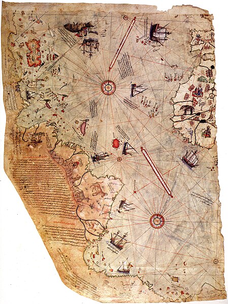
This would be remarkable since Antarctica was not officially discovered until 1820. But the more interesting claim comes from Charles Hutchins Hapgood who had a Master's degree in medieval history from Harvard. According to Hapgood, the map actually shows Antarctica as it appears without ice; that is, the map shows the landmass, not the visual cover of the water. That is remarkable since Antarctica has been ice-covered for thousands (actually millions) of years.
In the hands of ancient astronaut folks, this means that either the knowledge comes from ETs millions of years ago or a civilization with radar systems to map out the land rather than just the ice. Hapgood had different theories, including ancient human civilizations and fast-moving continents, but it still relies on the beliefs of what the Piri Re'is map shows.
But how good of a fit is the map to reality? Does it really show Antarctic landmass? We must first wonder if the mapmaker had access to great cartographic information since there are numerous mistakes for the continents known at the time. For example, the map mislabels Cuba as Hispaniola, which would be modern-day Haiti and the Dominican Republic, and apparently only half of the island is known. There are duplication of the Amazon River in South America, along with 900 missing miles of the continent's coastline. But closer to the area of interest, there is no gap between South America and "Antarctica", the Drake Passage between Cape Horn and the Antarctic Peninsula. That is already some serious issue with the map if it is from advanced civilizations, human or otherwise.
If we look at the region specified as a good match between the map and the continent, we are supposed to look at Queen Maud Land (highlighted in reddish pink).

How strong of a resemblance do you see between this region and the map image above? Doesn't look all that great to me. But here is the glue that held Hapgood's theory together. Already Hapgood had the idea that the ancients had mapped out this part of the world, and at a time when there wasn't ice covering the continent (or at least at the coasts). But with time the accuracy of the maps would be lost. So, given sufficient corrections, we can find that the map does fit the coast of Queen Maud Land. In other words, it's circular reasoning! (See also David C. Jolly, "Was Antarctica Mapped by the Ancients?," The Skeptical Inquirer Vol. 11 (Fall, 1986), pp. 32-43, 55.)
So the fit isn't great and mostly artificial. If anything, we may think that the continent in the south is an extension of South America, an understandable error for the 16th century. But this is not the only map with a southerly continent. In fact, the idea goes all the way back to antiquity. The notion seems to first crop up with Aristotle, and that region came to be known as Terra Australis, meaning southern land (the name is now effectively borne by Australia). The idea Aristotle had was not because of his excellent geographic knowledge, but rather an argument from symmetry (see Meteorology, Book 2.5). His argument is not about observations or old lore, but what the world must be like, given symmetrical notions and the winds. Hardly what we expect if the ancients had such knowledge. The Greeks and Romans also speculated if anyone actually lived below the deserts of North Africa, and so the maps of the time, such as that of Ptolemy, would incorporate the idea. Renaissance maps and globes would also include the continent, but wildly off from what we know today as correct.
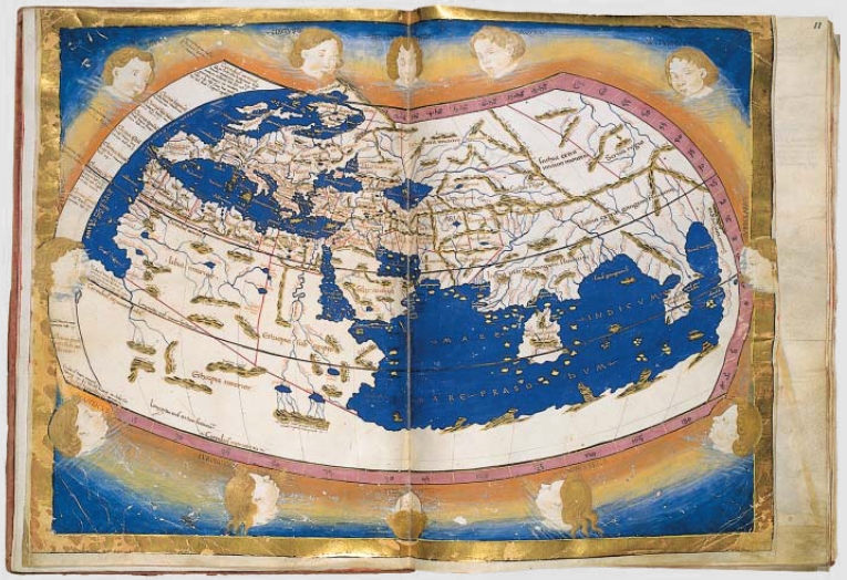 |
| Renaissance reconstruction of Ptolemy's map of the world (from his Geographia). Notice the landmass at the south of the Indian Ocean. |
 |
| A c. 1570 map by Abraham Ortelius. Antarctica had been putting on some weight it seems. |
.jpg/800px-Kunyu_Wanguo_Quantu_(%E5%9D%A4%E8%BC%BF%E8%90%AC%E5%9C%8B%E5%85%A8%E5%9C%96).jpg) |
| A 1604 Chinese Map. Obviously Terra Australis is a bit larger than what we know to be true. Perhaps there has been super-global warming? |
Oh, and if you think the problem is bad memory, well, here's a video of Al Franken drawing a map of the USA from memory.
Not bad, Al. Not bad.
No comments:
Post a Comment